Educational & Informational Home Stay
Visitor Information
About Molokai
- Location – In the heart of the Hawaiian islands. 26 (42km) miles southeast of Oahu and 8 (13km) miles west of Maui with Lanai 10 (16km) miles directly south. Located at about 21.15°N 157.10°W.
- Size – 261 square miles (676 square kilometers). About 37 miles long (60 km) and 10 (16km) miles wide.
- Shape – Three separate volcanoes created the island. Kamakou, in the east. is the tallest with a peak elevation of 4,970 feet (1813 meters). Maunaloa in the west rises to only 1,381 feet (503 meters). A third, smaller volcano created the Kalaupapa peninsula on the north shore. Height about 449 feet / 137m above sea level.
- Population – About 8,000. The majority live in Kaunakakai, the largest town, which is located on the south shore about in the middle of the island.
- Ethnicity – 60% Hawaiian or Hawaiian ancestry. 28% Filipino. 12% everyone else including Chinese, Japanese, Caucasian, Black, Samoan, Tongan and others.
Molokai Climate Information
Moloka’i weather is wonderful year round, with temperatures averaging about 75°F and rarely going 6 or 7 degrees above or below. In winter (Dec. thru Mar.), the night-time temperatures may drop to the lower 60s and you’re more likely to experience a rainy day.
Spring, summer, and fall are all very similar with warm days (up to 85°F) cooled by the trade winds and pleasant evenings in the mid to lower 70s. However, on those days when the trade winds are calm, the heat and humidity will both rise a notch or two.
Climate data from the Moloka’i Airport. Measurements are prior 25 year averages.
Average
Maximum
Temperature
| °C | °F | |
| Jan | 25.2 | 77.4 |
| Feb | 25.2 | 77.4 |
| Mar | 25.8 | 78.4 |
| Apr | 26.3 | 79.3 |
| May | 27.5 | 81.5 |
| Jun | 28.3 | 82.9 |
| Jul | 28.9 | 84.0 |
| Aug | 29.6 | 85.3 |
| Sep | 29.7 | 85.5 |
| Oct | 29.0 | 84.2 |
| Nov | 27.5 | 81.5 |
| Dec | 26.0 | 78.8 |
| Year | 27.5 | 81.5 |
Average
Minimum
Temperature
| °C | °F | |
| Jan | 17.8 | 64.0 |
| Feb | 17.5 | 63.5 |
| Mar | 18.1 | 64.6 |
| Apr | 19.0 | 66.2 |
| May | 19.8 | 67.6 |
| Jun | 20.9 | 69.6 |
| Jul | 21.5 | 70.7 |
| Aug | 21.7 | 71.1 |
| Sep | 21.6 | 70.9 |
| Oct | 21.2 | 70.2 |
| Nov | 20.1 | 68.2 |
| Dec | 18.6 | 65.5 |
| Year | 19.8 | 67.6 |
Average
Monthly
Rainfall
| mm | inches | |
| Jan | 107.8 | 4.2 |
| Feb | 85.7 | 3.4 |
| Mar | 78.7 | 3.1 |
| Apr | 55.9 | 2.2 |
| May | 33.3 | 1.3 |
| Jun | 12.1 | 0.5 |
| Jul | 18.4 | 0.7 |
| Aug | 17.6 | 0.7 |
| Sep | 21.4 | 0.8 |
| Oct | 57.5 | 2.3 |
| Nov | 85.1 | 3.4 |
| Dec | 114.1 | 4.5 |
| Year | 688.6 | 27.1 |
About Moloka’i – Map and Driving Instructions
Getting around Moloka’i is easy. The highway crosses the island from east end to west end with a couple of roads that branch off for short distances. It’s almost impossible to get lost.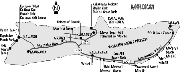
Even though it’s the same road, you’ll note from the map that it has two highway numbers: 450 and 460. Kamehameha V Highway (450) starts at Kaunakakai and ends 27 miles (43km) east at Halawa.
Maunaloa Highway (460) also begins at Kaunakakai, passes the airport at Ho’olehua and ends 16 miles (26km) west at the village of Maunaloa. Turn at mile 15 to reach the Kaluakoi Resort area. To get to Kualapu’u, Kala’e and the Kalaupapa lookout, take Highway 470 where it branches from 460 in the middle of the island.
There are green mile posts every mile. Directions to someone’s house, a resort, or a great beach usually include the nearest mile marker number or landmark. For example; “My house is east 6/10s past mile 12. Mauka (mountain) side” or “Wavecrest resort is at exactly mile 13 east, makai (ocean side).”
While the driving times below may seem a little high for the distance involved, they are based on some real life-on-Moloka’i factors. The highest posted speed limit anywhere on the island is 45mph (72kph) and in many places the speed limit is less.
Maunaloa to Kaunakakai – 16 miles (26km) – 25 minutes
Kaluakoi Resort to Kaunakakai – 22 miles (35km) – 35 minutes
Kaluakoi Resort to Kalaupapa lookout – 24 miles (38km) – 35 minutes
Kaluakoi Resort to Airport – 15 miles (24km) – 20 minutes
Kaunakakai to Wavecrest Resort – 13 miles (21km) – 20 minutes
Kaunakakai to Halawa – 27 miles (43km) – 50 minutes
Kaunakakai to Kalaupapa lookout – 10 miles (16km) – 20 minutes
Kaunakakai to Airport – 8 miles (13km) – 20 minutes
About Molokai – Transportation
While getting around the island is a breeze, sometimes getting here can be a challenge. On the smaller planes, there are luggage restrictions on weight. If you have items that you don’t need while on Molokai, there are secure services at the Honolulu Airport to store your baggage. Not a big deal, if you want to bring everything; however, expect a surcharge for any overweight baggage.
Airlines Serving Molokai
| Mokulele Airlines – All Islands | 808.495.4188 |
The easiest way to get around on Molokai is to rent a car. You need to rent in advance because we have a shortage of cars on weekends and during the winter. And you pay more when you don’t reserve in advance.
Shop around for the best price. Let us know if you have questions.
We try to greet all our guests at the airport to ensure no hassles and do an orientation of the island when you arrive so you can find and do the things you want on Molokai. I work outside the house, so I have to juggle the schedule and most of the time it works.
Alamo Car Rentals – The big guys at the airport.
Taxi
Hele Mai Taxi – 808.336.0967 Provides reliable, island-wide service with plenty of Aloha. They also offer exclusive, private island tours.
Bike Rental
Molokai Bicycle – 1.800.709.2453 Molokai is a great place to bike if you are in good shape and enjoy the challenge of some uphill travel.
More About Molokai
See VisitMolokai.com for more complete information about Moloka’i and things to do during your stay.